
Mumbai consists of two distinct regions: Mumbai City district and Mumbai Suburban district, which form two separate revenue districts of Maharashtra. The city district region is also commonly referred to as the Island City or South Mumbai. The total area of Mumbai is 603.4 km2 (233 sq mi). Of this, the island city spans 67.79 km2(26 sq mi), while the suburban district spans 370 km2 (143 sq mi), together accounting for 437.71 km2 (169 sq mi) under the administration of Brihanmumbai Municipal Corporation (BMC). The remaining area belongs to Defence, Mumbai Port Trust, Atomic Energy Commission and Borivali National Park, which are out of the jurisdiction of the BMC.
Mumbai lies at the mouth of the Ulhas River on the western coast of India, in the coastal region known as the Konkan. It sits on Salsette Island, partially shared with theThane district. Mumbai is bounded by the Arabian Sea to the west. Many parts of the city lie just above sea level, with elevations ranging from 10 m (33 ft) to 15 m (49 ft); the city has an average elevation of 14 m (46 ft). Northern Mumbai (Salsette) is hilly, and the highest point in the city is 450 m (1,476 ft) at Salsette in thePowai-Kanheri ranges. Sanjay Gandhi National Park (Borivali National Park) is located partly in the Mumbai suburban district, and partly in the Thane district, and it extends over an area of 103.09 km2 (39.80 sq mi).
Apart from the Bhatsa Dam, there are six major lakes that supply water to the city: Vihar, Lower Vaitarna, Upper Vaitarna, Tulsi, Tansa and Powai. Tulsi Lake and Vihar Lake are located in Borivili National Park, within the city's limits. The supply from Powai lake, also within the city limits, is used only for agricultural and industrial purposes. Three small rivers, the Dahisar River, Poinsar (or Poisar) and Ohiwara (or Oshiwara) originate within the park, while the polluted Mithi River originates from Tulsi Lake and gathers water overflowing from Vihar and Powai Lakes. The coastline of the city is indented with numerous creeks and bays, stretching from Thane creek on the eastern to Madh Marve on the western front. The eastern coast of Salsette Island is covered with large mangrove swamps, rich in biodiversity, while the western coast is mostly sandy and rocky.
Soil cover in the city region is predominantly sandy due to its proximity to the sea. In the suburbs, the soil cover is largely alluvial and loamy. The underlying rock of the region is composed of black Deccan basalt flows, and their acidic and basic variants dating back to the late Cretaceous and early Eocene eras. Mumbai sits on aseismically active zone owing to the presence of 23 fault lines in the vicinity. The area is classified as a Seismic Zone III region, which means an earthquake of up to magnitude 6.5 on the Richter-scale may be expected.
Climate
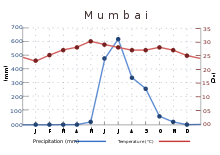
Mumbai has a tropical climate, specifically a tropical wet and dry climate under the Köppen climate classification, with seven months of dryness and peak of rains in July. The cold season from December to February is followed by the summer season from March to June. The period from June to about the end of September constitutes the south-west monsoon season, and October and November form the post-monsoon season.
Between June and September, the south west monsoon rains lash the city. Pre-monsoon showers are received in May. Occasionally, north-east monsoon showers occur in October and November. The maximum annual rainfall ever recorded was 3,452 mm (135.91 in) for 1954. The highest rainfall recorded in a single day was 944 mm (37.17 in) on 26 July 2005. The average total annual rainfall is 2,146.6 mm (84.51 in) for the Island City, and 2,457 mm (96.73 in) for the suburbs.
The average annual temperature is 27.2 °C (81 °F), and the average annual precipitation is 2,167 mm (85.31 in). In the Island City, the average maximum temperature is 31.2 °C (88 °F), while the average minimum temperature is 23.7 °C (75 °F). In the suburbs, the daily mean maximum temperature range from 29.1 °C (84 °F) to 33.3 °C (92 °F), while the daily mean minimum temperature ranges from 16.3 °C (61 °F) to 26.2 °C (79 °F) The record high is 40.2 °C (104 °F) (104.4 °F) on 28 March 1982, and the record low is 7.4 °C (45 °F) (45.3 °F) on 27 January 1962.
No comments:
Post a Comment