Sunday, May 15, 2011

Mumbai


Mumbai (मुंबई)
Bombay
—  Metropolitan city  —
Skyscrapers lit up at night. A clock tower with a square base and an octagonal top. A wide building with central and surrounding domes. Wide skyscrapers at night. A brown arch with boats nearby.
Clockwise from top: Skyline at Cuffe Parade, the Rajabai Clock Tower, the Taj Mahal Hotel, Nariman Point andGateway of India
Mumbai is on the west coast of India, about one third of the way down to the southern tip. It is in the west side of the Maharashtra province, which covers roughly the second quarter of the west coast (counting from the north), and heads inland roughly twice as far as its coastline.
Mumbai (मुंबई)
Location of Mumbai (मुंबई)
in Maharashtra and India
Coordinates18°58′30″N72°49′33″E
Former nameBombay
CountryIndia
StateMaharashtra
District(s)Mumbai City
Mumbai Suburban
Municipal commissionerSubodh Kumar
MayorShraddha Jadhav
Population
• Density
• Metro
12,478,447 (1st) (2011)
• 20,694 /km2 (53,597 /sq mi)
• 21,900,967 (1st) (2010)
Time zoneIST (UTC+5:30)
Area
• Elevation
603 km2 (233 sq mi)
• 14 metres (46 ft)
Websitewww.mcgm.gov.in
Mumbai ( Marathi: मुंबईMumbaīIPA: [mumbə.i]), formerly known as Bombay , is the capital of the Indian state ofMaharashtra. It is the most populous city in India, and the fifth most populous city in the world, with a population of approximately 12.5 million. Along with theneighbouring urban areas, including the cities of Navi Mumbai and Thane, it is one of the most populous urban regions in the world. Mumbai lies on the west coast of India and has a deep natural harbour. As of 2009, Mumbai was named an Alpha world city. Mumbai is also the richest city in India, and has the highest GDP of any city in South, West or Central Asia.
The seven islands that came to constitute Mumbai were home to communities of fishing colonies. For centuries, the islands came under the control of successiveindigenous empires before being ceded to the Portuguese and subsequently to the British East India Company. During the mid-18th century, Mumbai was reshaped by the British with large-scale civil engineering projects, and emerged as a significant trading town. Economic and educational development characterised the city during the 19th century. It became a strong base for the Indian independence movement during the early 20th century. When India became independent in 1947, the city was incorporated into Bombay State. In 1960, following the Samyukta Maharashtra movement, a new state of Maharashtra was created with Bombay as capital. It was renamed Mumbai in 1995.
Mumbai is the commercial and entertainment capital of India, generating 5% of India's GDP, and accounting for 25% of industrial output, 70% of maritime trade in India (Mumbai Port Trust & JNPT), and 70% of capital transactions to India's economy. Mumbai is home to important financial institutions such as the Reserve Bank of India, the Bombay Stock Exchange, the National Stock Exchange of India and the corporate headquarters of numerous Indian companies and multinational corporations. It houses some of India's premier scientific and nuclear institutes like BARC, NPCL, IREL, TIFR, AERB, AECI, and the Department of Atomic Energy. The city also houses India's Hindi (Bollywood) and Marathi film and television industry. Mumbai's business opportunities, as well as its potential to offer a higher standard of living, attract migrants from all over India and, in turn, make the city a potpourri of many communities and cultures.

Toponymy


The name Mumbai is an eponym, derived from Mumba or Maha-Amba—the name of the Koli goddess Mumbadevi—and Aai, "mother" in the language of Marathi.
The oldest known names for the city are Kakamuchee and Galajunkja; these are sometimes still used. Ali Muhammad Khan, in the Mirat-i-Ahmedi (1507) referred to the city as Manbai. In 1508, Portuguese writer Gaspar Correia used the name Bombaim, in his Lendas da Índia ("Legends of India"). This name possibly originated as the Old Portuguese phrase bom baim, meaning "good little bay", and Bombaim is still commonly used in Portuguese. In 1516, Portuguese explorer Duarte Barbosa used the name Tana-MaiambuTana appears to refer to the adjoining town of Thane and Maiambu to Mumbadevi.
The temple of local Hindu goddess Mumbadevi, after whom the city of Mumbai derives its name
Other variations recorded in the 16th and the 17th centuries include: Mombayn (1525), Bombay (1538), Bombain (1552), Bombaym (1552), Monbaym (1554),Mombaim (1563), Mombaym (1644), Bambaye (1666), Bombaiim (1666), Bombeye (1676), and Boon Bay (1690). After the British gained possession of the city in the 17th century, the Portuguese name was officially anglicised as Bombay.
By the late 20th century, the city was known as Mumbai or Mambai to Marathi and Gujarati speakers and as Bambai in Hindi, Persian and Urdu. The English name was officially changed to Mumbai in November 1995. This came at the insistence of the Marathi nationalist Shiv Sena party that had just won the Maharashtra state elections and mirrored similar name changes across the country. A theory was proposed suggesting that "Bombay" was a corrupted English version of "Mumbai" and an unwanted legacy of British colonial rule. The push to rename Bombay was part of a larger movement to strengthen Marathi identity in the Maharashtra region. However, the city is still referred to as Bombay by some of its residents and Indians from other regions as well. However, mentions of the city by the name other than Mumbai have been controversial, resulting in emotional outbursts sometimes of a violently political nature.
A widespread popular etymology of Bombay holds that it was derived from a Portuguese name meaning "good bay". This is based on the facts that bom is Portuguese for "good" and baía (or the archaic spelling bahia) means "bay". However, this literal translation would have been incorrect in grammatical gender, as bomis masculine, while baia is feminine; a correct Portuguese rendering of "good bay" would be boa ba(h)ia. Having said this, baim is an archaic, masculine word for "little bay"
Portuguese scholar José Pedro Machado in his Dicionário Onomástico Etimológico da Língua Portuguesa (1981; "Portuguese Dictionary of Onomastics and Etymology"), seems to reject the "Bom Bahia" hypothesis, suggesting that the presence of a bay was a coincidence (rather than a basis of the toponym) and led to a misconception, that the noun (bahia; "bay") was an integral part of the Portuguese name.

History


Early history

A white Buddhist stupa.
Kanheri Caves served as a centre of Buddhism in Western India during ancient times
Mumbai is built on what was once an archipelago of seven islands: Bombay Island, Parel, Mazagaon, Mahim, Colaba, Worli, and Old Woman's Island (also known as Little Colaba). Pleistocene sediments found along the coastal areas around Kandivali in northern Mumbai by archaeologist Todd in 1939 suggest that these islands were inhabited since the Stone Age. It is not exactly known when these islands were first inhabited. Perhaps at the beginning of the Common era (2000 years ago), or even possibly earlier, they came to be occupied by the Koli fishing community.
In the third century BCE, the islands formed part of the Maurya Empire, during its expansion in the south, ruled by the Buddhist emperor, Ashoka of Magadha. The Kanheri Caves in Borivali were excavated in the mid-third century BCE, and served as an important centre of Buddhism in Western India during ancient Times. The city then was known as Heptanesia (Ancient Greek: A Cluster of Seven Islands) to the Greek geographer Ptolemy in 150 CE.
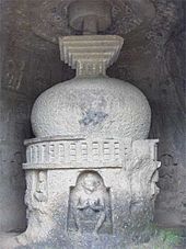
Between the second century BCE and ninth century CE, the islands came under the control of successive indigenous dynasties: Satavahanas, Western Kshatrapas, Abhiras,Vakatakas, Kalachuris, Konkan Mauryas, Chalukyas and Rashtrakutas, before being ruled by the Silhara dynasty from 810 to 1260. Some of the oldest edifices in the city built during this period are, Jogeshwari Caves (between 520 to 525), Elephanta Caves (between the sixth to seventh century), Walkeshwar Temple (10th century), andBanganga Tank (12th century).
King Bhimdev founded his kingdom in the region in the late 13th century, and established his capital in Mahikawati (present day Mahim). The Pathare Prabhus, one of the earliest known settlers of the city, were brought to Mahikawati from Saurashtra in Gujarat around 1298 by Bhimdev. The Delhi Sultanate annexed the islands in 1347–48, and controlled it till 1407. During this time, the islands were administered by the Muslim Governors of Gujarat, who were appointed by the Delhi Sultanate.
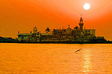
The Haji Ali Dargah was built in 1431, when Mumbai was under the rule of the Gujarat Sultanate
The islands were later governed by the independent Gujarat Sultanate, which was established in 1407. The Sultanate's patronage led to the construction of many mosques, prominent being the Haji Ali Dargah in Worli, built in honour of the Muslim saint Haji Ali in 1431. From 1429 to 1431, the islands were a source of contention between the Gujarat Sultanate and the Bahamani Sultanate of Deccan. In 1493, Bahadur Khan Gilani of the Bahamani Sultanate attempted to conquer the islands, but was defeated.


European rule

The Mughal Empire, founded in 1526, was the dominant power in the Indian subcontinent during the mid-16th century. Growing apprehensive of the power of the Mughal emperor Humayun, Sultan Bahadur Shah of the Gujarat Sultanate was obliged to sign the Treaty of Bassein with the Portuguese Empire on 23 December 1534. According to the treaty, the seven islands of Bombay, the nearby strategic town of Bassein and its dependencies were offered to the Portuguese. The territories were later surrendered on 25 October 1535.The Portuguese were actively involved in the foundation and growth of their Roman Catholic religious orders in Bombay.
Some of the oldest Catholic churches in the city such as the St. Michael's Church at Mahim (1534), St. John the Baptist Church at Andheri (1579), St. Andrew's Church at Bandra (1580), and Gloria Church at Byculla (1632), date from the Portuguese era. On 11 May 1661, the marriage treaty of Charles II of England andCatherine of Braganza, daughter of King John IV of Portugal, placed the islands in possession of the British Empire, as part of Catherine's dowry to Charles. However,Salsette, Bassein, Mazagaon, Parel, Worli, Sion, Dharavi, and Wadala still remained under Portuguese possession. From 1665 to 1666, the British managed to acquire Mahim, Sion, Dharavi, and Wadala.
These islands were in turn leased to the British East India Company in 1668 for a sum of £10 per annum by the Royal Charter of 27 March 1668. The population quickly rose from 10,000 in 1661, to 60,000 in 1675. The islands were subsequently attacked by Yakut Khan, the Siddi admiral of the Mughal Empire, in October 1672,Rickloffe van Goen, the Governor-General of Dutch India on 20 February 1673, and Siddi admiral Sambal on 10 October 1673.
In 1687, the British East India Company transferred its headquarters from Surat to Bombay. The city eventually became the headquarters of the Bombay Presidency.Following the transfer, Bombay was placed at the head of all the Company's establishments in India. Towards the end of the 17th century, the islands again suffered incursions from Yakut Khan in 1689–90. The Portuguese presence ended in Bombay when the Marathas under Peshwa Baji Rao I captured Salsette in 1737, andBassein in 1739.
By the middle of the 18th century, Bombay began to grow into a major trading town, and received a huge influx of migrants from across India. Later, the British occupied Salsette on 28 December 1774. With theTreaty of Surat (1775), the British formally gained control of Salsette and Bassein, resulting in the First Anglo-Maratha War. The British were able to secure Salsette from the Marathas without violence through the Treaty of Purandar(1776),and later through the Treaty of Salbai (1782), signed to settle the outcome of the First Anglo-Maratha War.
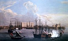
Ships in Bombay Harbour (c. 1731). Bombay emerged as a significant trading town during the mid-18th century.
From 1782 onwards, the city was reshaped with large-scale civil engineering projects aimed at merging all the seven islands into a single amalgamated mass. This project, known as Hornby Vellard, was completed by 1784. In 1817, the British East India Company under Mountstuart Elphinstone defeated Baji Rao II, the last of the MarathaPeshwa in the Battle of Khadki. Following his defeat, almost the whole of the Deccan came under British suzerainty, and were incorporated in Bombay Presidency. The success of the British campaign in the Deccan witnessed the freedom of Bombay from all attacks by native powers.
By 1845, the seven islands were coalesced into a single landmass by the Hornby Vellard project. On 16 April 1853, India's first passenger railway line was established, connecting Bombay to the neighbouring town of Thane. During the American Civil War (1861–1865), the city became the world's chief cotton trading market, resulting in a boom in the economy that subsequently enhanced the city's stature.
The opening of the Suez Canal in 1869 transformed Bombay into one of the largest seaports on the Arabian Sea. In September 1896, Bombay was hit by a bubonic plague epidemic where the death toll was estimated at 1,900 people per week. About 850,000 people fled Bombay and the textile industry was adversely affected.As the capital of the Bombay Presidency, it witnessed the Indian independence movement, with the Quit India Movement in 1942 and The Royal Indian Navy Mutiny in 1946 being its most notable events.


Independent India

A stone statue of torch-bearers as seen at night. A fountain with a white base is in the background
The 
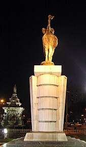
Hutatma Chowk memorial, built to honour the martyrs of theSamyukta Maharashtra movement. (Flora Fountain is on its left in the background.)
After India's independence in 1947, the territory of the Bombay Presidency retained by India was restructured into Bombay State. The area of Bombay State increased, after several erstwhile princely states that joined the Indian union were integrated into the state. Subsequently, the city became the capital of Bombay State. On April 1950, Municipal limits of Bombay were expanded by merging the Bombay Suburban District and Bombay City to form Greater Bombay Municipal Corporation.
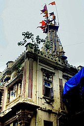
The Samyukta Maharashtra movement to create a separate Maharashtra state including Bombay was at its height in the 1950s. In the Lok Sabha discussions in 1955, theCongress party demanded that the city be constituted as an autonomous city-state. The States Reorganisation Committee recommended a bilingual state for Maharashtra–Gujarat with Bombay as its capital in its 1955 report. Bombay Citizens' Committee, an advocacy group of leading Gujarati industrialists lobbied for Bombay's independent status.
Following protests during the movement in which 105 people were killed by police, Bombay State was reorganised on linguistic lines on 1 May 1960. Gujarati-speaking areas of Bombay State were partitioned into the state of Gujarat. Maharashtra State with Bombay as its capital was formed with the merger of Marathi-speaking areas of Bombay State, eight districts from Central Provinces and Berar, five districts from Hyderabad State, and numerous princely states enclosed between them. As a memorial to the martyrs of the Samyukta Maharashtra movement, Flora Fountain was renamed as Hutatma Chowk (Martyr's Square), and a memorial was erected.
The following decades saw massive expansion of the city and its suburbs. In the late 1960s, Nariman Point and Cuffe Parade were reclaimed and developed. The Bombay Metropolitan Region Development Authority (BMRDA) was set up on 26 January 1975 by the Government of Maharashtra as an apex body for planning and co-ordination of development activities in the Bombay metropolitan region. In August 1979, a sister township of New Bombay was founded by City and Industrial Development Corporation(CIDCO) across Thane and Raigad districts to help the dispersal and control of Bombay's population. Textile industry in Bombay largely disappeared after the massive 1982Great Bombay Textile Strike, in which nearly 250,000 workers in more than 50 textile mills went on strike. Mumbai's defunct cotton mills have since become the focus ofintense redevelopment.
The Jawaharlal Nehru Port, which currently handles 55–60% of India's containerized cargo, was commissioned on 26 May 1989 at Nhava Sheva with a view to de-congest Bombay Harbour and to serve as a hub port for the city. The geographical limits of Greater Bombay were coextensive with municipal limits of Greater Bombay. On 1 October 1990, the Greater Bombay district was bifurcated to form two revenue districts namely, Bombay City and Bombay Suburban, though they were administered by same Municipal Administration.
The past two decades have seen an increase in violence in the hitherto largely peaceful city. Following the demolition of the Babri Masjid in Ayodhya, the city was rocked by the Hindu-Muslim riots of 1992–93 in which more than 1,000 people were killed. On 12 March 1993, a series of 13 co-ordinated bombings at several city landmarks by Islamic extremists and the Bombay underworld resulted in 257 deaths and over 700 injuries. In 2006, 209 people were killed and over 700 injured when seven bombs exploded on the city's commuter trains.
In 2008, a series of ten coordinated attacks by armed terrorists for three days resulted in 173 deaths, 308 injuries, and severe damage to a couple of heritage landmarks and prestigious hotels. Today, Mumbai is the commercial capital of India and has evolved into a global financial hub. For several decades it has been the home of India's main financial services, and a focus for both infrastructure development and private investment. From being an ancient fishing community and a colonial centre of trade, Mumbai has become South Asia's largest city and home of the world's most prolific film industry.

Geography


Mumbai is on a narrow peninsula on the southwest of Salsette Island, which lies between the Arabian Sea to the west, Thane Creek to the east, and Vasai Creek to the north. Mumbai's suburban district occupies most of the island. Navi Mumbai is east of Thane Creek, and the Thane District is north of Vasai Creek.
Mumbai consists of two revenue districts.
Mumbai consists of two distinct regions: Mumbai City district and Mumbai Suburban district, which form two separate revenue districts of Maharashtra. The city district region is also commonly referred to as the Island City or South Mumbai. The total area of Mumbai is 603.4 km2 (233 sq mi). Of this, the island city spans 67.79 km2(26 sq mi), while the suburban district spans 370 km2 (143 sq mi), together accounting for 437.71 km2 (169 sq mi) under the administration of Brihanmumbai Municipal Corporation (BMC). The remaining area belongs to Defence, Mumbai Port Trust, Atomic Energy Commission and Borivali National Park, which are out of the jurisdiction of the BMC.
Mumbai lies at the mouth of the Ulhas River on the western coast of India, in the coastal region known as the Konkan. It sits on Salsette Island, partially shared with theThane district. Mumbai is bounded by the Arabian Sea to the west. Many parts of the city lie just above sea level, with elevations ranging from 10 m (33 ft) to 15 m (49 ft); the city has an average elevation of 14 m (46 ft). Northern Mumbai (Salsette) is hilly, and the highest point in the city is 450 m (1,476 ft) at Salsette in thePowai-Kanheri ranges. Sanjay Gandhi National Park (Borivali National Park) is located partly in the Mumbai suburban district, and partly in the Thane district, and it extends over an area of 103.09 km2 (39.80 sq mi).
Apart from the Bhatsa Dam, there are six major lakes that supply water to the city: Vihar, Lower Vaitarna, Upper Vaitarna, Tulsi, Tansa and Powai. Tulsi Lake and Vihar Lake are located in Borivili National Park, within the city's limits. The supply from Powai lake, also within the city limits, is used only for agricultural and industrial purposes. Three small rivers, the Dahisar River, Poinsar (or Poisar) and Ohiwara (or Oshiwara) originate within the park, while the polluted Mithi River originates from Tulsi Lake and gathers water overflowing from Vihar and Powai Lakes. The coastline of the city is indented with numerous creeks and bays, stretching from Thane creek on the eastern to Madh Marve on the western front. The eastern coast of Salsette Island is covered with large mangrove swamps, rich in biodiversity, while the western coast is mostly sandy and rocky.
Soil cover in the city region is predominantly sandy due to its proximity to the sea. In the suburbs, the soil cover is largely alluvial and loamy. The underlying rock of the region is composed of black Deccan basalt flows, and their acidic and basic variants dating back to the late Cretaceous and early Eocene eras. Mumbai sits on aseismically active zone owing to the presence of 23 fault lines in the vicinity. The area is classified as a Seismic Zone III region, which means an earthquake of up to magnitude 6.5 on the Richter-scale may be expected.


Climate

The average temperature ranges between 23 °C (73 °F) in January to 30 °C (86 °F) in May. Rainfall is at or near zero from November through May, then quickly rises to a peak of about 600 mm (23.62 in) in July, falling back more gradually.
Average temperature and precipitation in Mumbai
Mumbai has a tropical climate, specifically a tropical wet and dry climate under the Köppen climate classification, with seven months of dryness and peak of rains in July. The cold season from December to February is followed by the summer season from March to June. The period from June to about the end of September constitutes the south-west monsoon season, and October and November form the post-monsoon season.
Between June and September, the south west monsoon rains lash the city. Pre-monsoon showers are received in May. Occasionally, north-east monsoon showers occur in October and November. The maximum annual rainfall ever recorded was 3,452 mm (135.91 in) for 1954. The highest rainfall recorded in a single day was 944 mm (37.17 in) on 26 July 2005. The average total annual rainfall is 2,146.6 mm (84.51 in) for the Island City, and 2,457 mm (96.73 in) for the suburbs.
The average annual temperature is 27.2 °C (81 °F), and the average annual precipitation is 2,167 mm (85.31 in). In the Island City, the average maximum temperature is 31.2 °C (88 °F), while the average minimum temperature is 23.7 °C (75 °F). In the suburbs, the daily mean maximum temperature range from 29.1 °C (84 °F) to 33.3 °C (92 °F), while the daily mean minimum temperature ranges from 16.3 °C (61 °F) to 26.2 °C (79 °F) The record high is 40.2 °C (104 °F) (104.4 °F) on 28 March 1982, and the record low is 7.4 °C (45 °F) (45.3 °F) on 27 January 1962.

Economy


Mumbai is India's largest city (by population) and is the financial and commercial capital of the country as it generates 6.16% of the total GDP. It serves as an economic hub of India, contributing 10% of factory employment, 25% of industrial output, 33% of income tax collections, 60% of customs duty collections, 20% of central excise tax collections, 40% of India's foreign trade and Indian Rupee symbol.svg4,000 crore (US$888 million)in corporate taxes.
As of 2008, Mumbai's GDP is Indian Rupee symbol.svg919,600 crore (US$204.15 billion), and its per-capita income in 2009 was Indian Rupee symbol.svg128,000 (US$2,840), which is almost three times the national average. Many of India's numerous conglomerates (including Larsen and Toubro, State Bank of India, Life Insurance Corporation of India, Tata Group, Godrej and Reliance), and five of the Fortune Global 500 companies are based in Mumbai.Many foreign banks and financial institutions also have branches in this area, with the World Trade Centre being the most prominent one.
Until the 1970s, Mumbai owed its prosperity largely to textile mills and the seaport, but the local economy has since been diversified to include engineering, diamond-polishing, healthcare and information technology.As of 2008, the Globalization and World Cities Study Group (GaWC) has ranked Mumbai as an "Alpha world city", third in its categories of Global cities. Mumbai is the 4th most expensive office market in the world. Mumbai was ranked among the fastest cities in India for business startup in 2009.
India's 400 million strong middle-class population is growing at an annual rate of 5%. Shown here is an upmarket residential area of Mumbai.
State and central government employees make up a large percentage of the city's workforce. Mumbai also has a large unskilled and semi-skilled self employed population, who primarily earn their livelihood as hawkers, taxi drivers, mechanics and other such blue collar professions. The port and shipping industry is well established, withMumbai Port being one of the oldest and most significant ports in India. In Dharavi, in central Mumbai, there is an increasingly large recycling industry, processing recyclable waste from other parts of the city; the district has an estimated 15,000 single-room factories.
Most of India's major television and satellite networks, as well as its major publishing houses, are headquartered in Mumbai. The centre of the Hindi movie industry, Bollywood, is the largest film producer in India and one of the largest in the world as well as centre of Marathi Film Industry. Along with the rest of India, Mumbai, its commercial capital, has witnessed an economic boom since the liberalisation of 1991, the finance boom in the mid-nineties and the IT, export, services and outsourcing boom in 2000s.
Mumbai has been ranked 48th on the Worldwide Centres of Commerce Index 2008. In April 2008, Mumbai was ranked seventh in the list of "Top Ten Cities for Billionaires" by Forbes magazine, and first in terms of those billionaires' average wealth.

Civic administration


A brown building with a central tower and sloping roofs surrounded by trees. A grassy ground and a coconut tree are in front of it.
The Bombay High Court exercises jurisdiction over Maharashtra, Goa, Daman and Diu, and Dadra and Nagar Haveli.
Mumbai, extending from Colaba in the south, to Mulund and Dahisar in the north, and Mankhurd in the east, is administered by the Brihanmumbai Municipal Corporation(BMC). The BMC is in charge of the civic and infrastructure needs of the metropolis. The Mayor is usually chosen through indirect election by the councillors from among themselves for a term of two and half years.
The Municipal Commissioner is the chief Executive Officer and head of the executive arm of the Municipal Corporation. All executive powers are vested in the Municipal Commissioner who is an Indian Administrative Service (IAS) officer appointed by the state government. Although the Municipal Corporation is the legislative body that lays down policies for the governance of the city, it is the Commissioner who is responsible for the execution of the policies. The Commissioner is appointed for a fixed term as defined by state statute. The powers of the Commissioner are those provided by statute and those delegated by the Corporation or the Standing Committee.
The two revenue districts of Mumbai come under the jurisdiction of a District Collector. The Collectors are in charge of property records and revenue collection for theCentral Government, and oversee the national elections held in the city.
The Mumbai Police is headed by a Police Commissioner, who is an Indian Police Service (IPS) officer. The Mumbai Police comes under the state Home Ministry. The city is divided into seven police zones and seventeen traffic police zones,each headed by a Deputy Commissioner of Police. The Traffic Police is a semi-autonomous body under the Mumbai Police. The Mumbai Fire Brigade department is headed by the Chief Fire Officer, who is assisted by four Deputy Chief Fire Officers and six Divisional Officers.
Mumbai is the seat of the Bombay High Court, which exercises jurisdiction over the states of Maharashtra and Goa, and the Union Territories of Daman and Diu and Dadra and Nagar Haveli. Mumbai also has two lower courts, the Small Causes Court for civil matters, and the Sessions Court for criminal cases. Mumbai also has a special TADA (Terrorist and Disruptive Activities) court for people accused of conspiring and abetting acts of terrorism in the city.

Politics


Men in traditional Indian dresses posing for a photograph
First session of the Indian National Congress in Bombay (28–31 December 1885)
Mumbai has been a traditional stronghold and birthplace of the Indian National Congress, also known as the Congress Party. The first session of the Indian National Congress was held in Bombay from 28–31 December 1885. The city played host to the Indian National Congress six times during its first 50 years, and became a strong base for the Indian independence movement during the 20th century.
The 1960s saw the rise of regionalist politics in Bombay, with the formation of the Shiv Sena on 19 June 1966, out of a feeling of resentment about the relative marginalisation of the native Marathi people in Bombay. The party headed a campaign to expel South Indian and North Indian migrants by force.The Congress had dominated the politics of Bombay from independence until the early 1980s, when the Shiv Sena won the 1985 Bombay municipal corporation elections.
In 1989, the Bharatiya Janata Party (BJP), a major national political party, forged an electoral alliance with the Shiv Sena to dislodge the Congress in the MaharashtraLegislative Assembly elections. In 1999, the Nationalist Congress Party (NCP) separated from the Congress, but later allied with the Congress, to form a joint venture known as the Democratic Front. Currently, other parties such as Maharashtra Navnirman Sena (MNS), Samajwadi Party (SP), Bahujan Samaj Party (BSP), and several independent candidates also contest elections in the city.
In the Indian national elections held every five years, Mumbai is represented by six parliamentary constituencies: Mumbai North, Mumbai North West, Mumbai North East,Mumbai North Central, Mumbai South Central, and Mumbai South. A Member of Parliament (MP) to the Lok Sabha, the lower house of the Indian Parliament, is elected from each of the parliamentary constituencies. In the 2009 national elections, out of the six parliamentary constituencies, five were won by the Congress, and one by the NCP. In the Maharashtra state assembly elections held every five years, Mumbai is represented by 36 assembly constituencies.
A Member of the Legislative Assembly (MLA) to the Maharashtra Vidhan Sabha (Legislative Assembly) is elected from each of the assembly constituencies. In the 2009 state assembly elections, out of the 36 assembly constituencies, 17 were won by the Congress, 6 by the MNS, 5 by the BJP, 4 by the Shiv Sena, 3 by the NCP and 1 by SP. Elections are also held every five years to elect corporators to power in the BMC.
The Corporation comprises 227 directly elected Councillors representing the 24 municipal wards, five nominated Councillors having special knowledge or experience in municipal administration, and a Mayor whose role is mostly ceremonial. In the 2007 municipal corporation elections, out of the 227 seats, the Shiv Sena-BJP alliance secured 111 seats, holding power in the BMC, while the Congress-NCP alliance bagged 85 seats. The tenure of the Mayor, Deputy Mayor, and Municipal Commissioner is two and a half years.

Transport


Public transport

A red bus on a road. Blue letters are seen on its side
A BEST Starbus. BEST buses carry a total of 4.5 million passengers daily.
Public transport systems in Mumbai include the Mumbai Suburban Railway, Brihanmumbai Electric Supply and Transport (BEST) buses, black and yellow metered taxis,auto rickshaws and ferries. Suburban railway and BEST bus services together accounted for about 88% of the passenger traffic in 2008. Auto rickshaws are allowed to operate only in the suburban areas of Mumbai, while taxis are allowed to operate throughout Mumbai, but generally operate in South Mumbai.
Taxis and rickshaws in Mumbai are required by law to run on compressed natural gas, and are a convenient, economical, and easily available means of transport.Mumbai had about 1.53 million vehicles in 2008, 56,459 black and yellow taxis, and 102,224 auto rickshaws, as of 2005.


Road

The Bandra-Worli Sea Link is a cable-stayed bridge that connects central Mumbai with its western suburbs
Mumbai is served by National Highway 3, National Highway 4 and National Highway 8 of India's National Highways system. The Mumbai-Pune Expressway was the first expressway built in India, while the Mumbai-Vadodara Expressway, Western Freeway and Eastern Freeway is under construction. The Bandra-Worli Sea Link bridge, along with Mahim Causeway, links the island city to the western suburbs. The three major road arteries of the city are the Eastern Express Highway from Sion to Thane, the Sion Panvel Expressway from Sion to Panvel and the Western Express Highway from Bandra to Borivali.
Mumbai's bus services carried over 5.5 million passengers per day in 2008. Public buses run by BEST cover almost all parts of the metropolis, as well as parts ofNavi Mumbai, Mira-Bhayandar and Thane. The BEST operates a total of 4,013 buses with CCTV Camera installed, ferrying 4.5 million passengers daily over 390 routes. Its fleet consists of single-decker, double-decker, vestibule, low-floor, disabled-friendly, air-conditioned and Euro III compliantCompressed Natural Gas powered buses. Maharashtra State Road Transport Corporation (MSRTC) buses provide intercity transport and connect Mumbai with other major cities of Maharashtra and India. Navi Mumbai Municipal Transport (NMMT) also operate its Volvo buses in Mumbai, from Navi Mumbai to Bandra, Dindoshi and Borivali.
Buses are generally favored for commuting short to medium distances, while train fares are more economical for longer distance commutes.
The Mumbai Darshan is a tourist bus service which explores numerous tourist attractions in Mumbai. Mumbai BRTS (Bus Rapid Transit System) lanes have been planned throughout Mumbai, with buses running on seven routes as of March 2009. Though 88% of the city's commuters travel by public transport, Mumbai still continues to struggle with traffic congestion. Mumbai's transport system has been categorized as one of the most congested in the world.
  • Mumbai Skywalks
Because of congestion on roads due to hawkers and parked vehicles, MMRDA has initiated the Mumbai Skywalks project to provide quick and safe pedestrian dispersal from highly congested areas such asMumbai Suburban Railway stations to heavily targeted destinations.


Rail

A brown building with clock towers, domes and pyramidal tops. A wide street in front of it
The Chhatrapati Shivaji Terminus, formerly known as Victoria Terminus, is the headquarters of the Central Railway and aUNESCO World Heritage Site.
Mumbai is the headquarters of two of Indian Railways' zones: the Central Railway (CR) headquartered at Chhatrapati Shivaji Terminus (formerly Victoria Terminus), and theWestern Railway (WR) headquartered at Churchgate. The backbone of the city's transport, the Mumbai Suburban Railway, consists of three separate rail networks: Central, Western, and Harbour Line, running the length of the city, in the north-south direction.
Mumbai's suburban rail systems carried a total of 6.3 million passengers every day in 2007, which is more than half of the Indian Railways daily carrying capacity. Trains are overcrowded during peak hours, with nine-car trains of rated capacity 1,700 passengers, actually carrying around 4,500 passengers at peak hours. The Mumbai rail network is spread at an expanse of 319 route kilometers. 191 rakes(ratin-sets) of 9 car and 12 car composition are utilized to run a total of 2226 train services.
  • Mumbai Metro
Mumbai Metro is an underground and elevated rapid transit system currently under construction.
  • Mumbai Monorail
The Mumbai Monorail, currently under construction, will eventually run from Jacob Circle to Wadala.
Mumbai is well connected to most parts of India by the Indian Railways. Long-distance trains originate from Chhatrapati Shivaji Terminus, Dadar Station, Lokmanya Tilak Terminus, Mumbai Central Station, Bandra Terminus, Andheri and Borivali.


Air

Chhatrapati Shivaji International Airport is currently India's busiest airport in term of passenger traffic.
The Chhatrapati Shivaji International Airport (formerly Sahar International Airport) is the main aviation hub in the city and the busiest airport in India in terms of passenger traffic. In 2007, it catered to over 25 million passengers. An upgrade plan initiated in 2006, targeted at increasing the capacity of the airport to handle up to 40 million passengers annually by 2010, is expected to be completed on time.
The proposed Navi Mumbai International Airport to be built in the Kopra-Panvel area has been sanctioned by the Indian Government and will help relieve the increasing traffic burden on the existing airport.
The Juhu Aerodrome was India's first airport, and now hosts a flying club and a heliport.


Sea

Jawaharlal Nehru Port Trust is the busiest port in India
Mumbai is served by two major ports, Mumbai Port Trust and Jawaharlal Nehru Port Trust, which lies just across the creek inNavi Mumbai. Mumbai Port has one of the best natural harbours in the world, and has extensive wet and dry dock accommodation facilities. Jawaharlal Nehru Port, commissioned on 26 May 1989, is the busiest and most modern major port in India. It handles 55–60% of the country's total containerized cargo.
Mumbai is the headquarters of the Western Naval Command, and also an important base for the Indian Navy.
Ferries from Ferry Wharf in Mazagaon allow access to islands near the city.